24.11.08

A short break again


I will make a break for about two weeks. I’m off to Venice where, as an additional pleasure, I will also meet some other bloggers. More bridges to be posted about!

This is how Monet saw Venice.

21.11.08

... and now the last Seine bridges!

We have now reached the last episode of bridge serial. Five bridges are missing: Pont Mirabeau, Pont de Grenelle, Pont du Garigliano, Pont de Tolbiac and Pont National. (There are actually two more, the ones used by the circular road, the “Périphérique”… and I will briefly mention them.)

This is where you can find the missing ones (coming back to the original plan, see the white circles):
I already made a post about Pont Mirabeau, so just a few words. As we are now already quite distant from what used to be the centre of the city, this bridge which dates from 1896 is the first one here. When it was constructed it was the longest and highest of the Paris bridges ... and I think it’s still one of the most beautiful ones. For a French citizen the name of the bridge is closely linked to a famous poem by Guillaume Appolinaire: “Sous le Pont Mirabeau coule la Seine...” (Under the Mirabeau Bridge flows the Seine...”). The bridge got its name from the Count de Mirabeau, one of the Revolution personalities. The top picture shows the Pont Mirabeau in the front line, followed by Pont Rouelle and Pont de Bir-Hakeim.
The Pont de Grenelle is recent (1966), replacing a first one from 1873. As Pont de Bir-Hakeim (see previous post) and Pont Rouelle (see previous post) it crosses the Ile des Cygnes (Swan Island) at its southern end where you also find the Paris copy of the Statue of Liberty (see previous posts), a gift by the Paris American colony in 1889, looking in the direction of its bigger sister.

The bridge got its name from the close-by Grenelle area and street. (Grenelle comes from the Latin word Garanella, meaning a wooded area with rabbits.)
Also Pont du Garigliano is a modern bridge (1966). Here you found earlier a bridge from 1865 in two levels, similar to Pont de Bercy (see previous post), the second level used by the 19th century circular railway (“Petite Ceinture”, see previous post). It was called Viaduc d’Auteuil or Point-du-Jour. No trains pass here anymore. The previous bridge was bombed twice, once in 1870, and a second time, as the only Paris bridge during WW II, in 1943. The name of the present bridge comes from another battle victory, a more recent one, in Italy in 1944.

The bridge has recently got a special decoration, a “Telephone Both” designed by Frank O. Gehry (see previous post). This was linked to an attempt to create temporary art along the new Paris tramway line (see previous post), which has one of its temporary end points here.
We are now going far upstream to the Pont de Tolbiac from 1882. It was the first bridge here and was needed because of a too long distance between the surrounding bridges. The bridge got its name from a battle – once more – but a very ancient one, in 496 (Tulpiacum, probably Zülpich in North Rhine-Westphalia nowadays).

On the northern, right bank, the bridge brings you to the Bercy Park (see previous post). An aeroplane belonging to the Free Forces crashed close to the bridge in 1943 after having been hit by the German forces.
The (almost) last bridge will be Pont National. It was originally, in 1853, built also to take care of the rail traffic for the “Petite Ceinture” under the name Pont Napoleon III, but here road and rail ran side by side. You can still see the now abandoned rails. In 1870 it got its present name (Napoleon III was not anymore in grace). It was widened during the war years, opened in 1944 with its present width.

A lot of transformation takes place at the moment between Pont de Tolbiac and Pont National, restructuring a previous very industrial area.
To finish with the Seine bridges I would just like to mention and show the two bridges that were built for the ring road, the “Périphérique”, completed in 1973. The one to the right is upstream, the one to the left downstream.
(I trust that I have now covered all the bridges!!)

You can find these pictures “in full” and as a slide show on Ipernity.

After this bridge series I need a weekend! I hope that yours will be nice!

20.11.08

... and even more Seine bridges

I would like to finish with the bridges this week. This means that I will exceptionally make a post also today, a Thursday. Tomorrow you will have the last bridge post!! In the meantime I'm rather busy with visitors this week; hardly any time to visit your blogs. I will be back looking and commenting later!

This one will be about three bridges: Pont d’Austerlitz, Pont Charles de Gaulle and Pont de Bercy (the ones in yellow on this map).


The Pont d’Austerlitz dates from the first years of the 19th century, the Napoleon I times. The original version which you can see below was later considered too narrow and dangerous and it has been reinforced and widened since; a first time in 1854, a second time in 1885. The name comes of course - once more - from a Napoleon battle victory, against the Russians and the British, in 1805. As we can see from the above map, this bridge leads not only to the Gare (Station) d’Austerlitz , but also to the Jardin (Garden) des Plantes, the French major botanical garden, definitely worth a visit, not only for the plants, but also for several museums, an aquarium and a zoo. (I will make a post about it soon.)
The Pont d’Austerlitz had a very heavy traffic and more was to come with an at present ongoing development of the upstream left bank of the Seine. It was thus decided to create a new bridge. The Pont Charles de Gaulle dates from 1996 and offers a new much more direct connection between the Gare de Lyon and the Gare d’Austerlitz. The two bridges are one way (except if you walk or bike of course). I guess there is no need to explain the name of the bridge.

The last bridge for today will be Pont de Bercy (see previous post). The present bridge is from 1864 and it then replaced a previous one from 1832. It was enlarged in 1904 in order to also allow a second level, for the metro (line 6). The concept here is the same as with the Pont Bir-Hakeim (see previous post) allowing a combination of metro and other traffic. In 1992 the bridge doubled in width, keeping the original general aspect. As mentioned earlier, different new activities in this part of the city led to highly increased need of river passages. This included of course some features from the 80’s and 90's that we can see in the immediate neighbourhood of the bridge – the Ministry of Finance (leaving a wing of the Louvre for this modern complex), a new multi–sport arena also used for concerts, both mostly just called “Bercy”, a new building for the National Library (Bibliothèque François Mitterrand)... and a lot more, on both sides of the river. The picture on the top shows you the Pont de Bercy and the Ministry of Finance.
You can find these photos "in full" and as a slide show on Ipernity.

19.11.08

... and even even more Seine bridges


(I know, these bridge posts are too long, but I want to finish will all the bridges as soon as possible and change subjects ... and there are 37 of them. Only a few bridges left now, soon finished... be patient, please! This means however that I will exceptionally make a post tomorrow, Thursday... I want to finish this week!)
Today, it’s time for the missing bridges connecting the Seine banks with Ile de la Cité: Pont de Notre Dame, Petit Pont, Pont de Change, Pont Saint Michel and Pont Neuf.

The Pont de Notre Dame is definitely not the oldest still existing bridge in Paris (it’s Pont Neuf), but it’s situated where the first bridge was built. Here is an illustration of what Paris looked like during the Roman times (see this excellent site). Its first name was the Grand Pont (Big Bridge), to be seen in combination with the more or less as old bridge on the opposite side of the island, the Petit Pont (Small Bridge). Different floods, and the Vikings, destroyed the first bridges. Around 1420 what was supposed to be a solid wooden bridge was ready and got the name of Notre Dame, however it collapsed in 1499. In 1507 the first stone bridge, with buildings on top was ready.

On the picture below we can see what Paris looked like around 1760 and in the small insert we can see a painting of the Pont Notre Dame, also around 1760. The Pont Notre Dame was one of many bridges with buildings on top those days. Around 1788, just before the Revolution, all houses were gone on the Paris bridges (too heavy, too risky). 
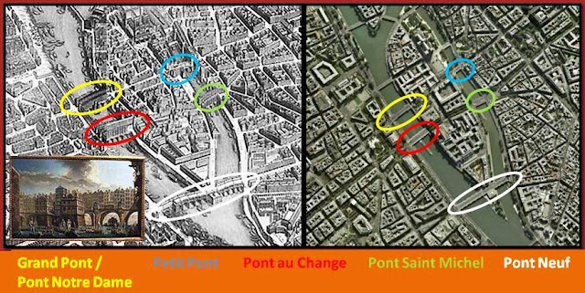
A new bridge was built in 1853, but it did not last long – too many arches, too narrow and too many navigation accidents. The bridge we see today, a one-arch steel bridge, is from 1919.

Despite its name, it’s not the bridge which is the closest to the Notre Dame Cathedral, but when it got its name, all the other bridges were not there, ... but Notre Dame was.

As already indicated above, the prolongation to the Pont Notre Dame, ex Grand Pont, on the other side of Ile de la Cité, is the Petit Pont. This bridge has been rebuilt at least thirteen times, although the first stone version, supposed to be solid, came already during the 12th century. The present stone bridge in one arch is from 1853.

This is the bridge most tourist use on their way between Notre Dame and the Quartier Latin. (I would however recommend the Pont au Double (see previous post).

The Pont au Change competes with the Pont Notre Dame to once upon the time has been the original Grand Pont. Actually, it may not be quite certain where exactly between these two bridges the very first one was constructed. Several bridges have existed here. The 1647 version (which we also can see on the old picture above) was then the largest bridge in Paris. Before the buildings were demolished, this was the place where jewellers, goldsmiths... and money-brokers were installed, which explains the present name of the bridge.

The present bridge dates from 1860 and will take you from Place du Châtelet (see previous post) on the right bank to the Palais de Justice and the Conciergerie (see previous posts) on the island and there I would draw your special attention to the clock on the wall of the square Tour d’Horloge (Clock Tower). It dates from 1585 ... and it works. This one replaces the first original wall clock in Paris from 1370.

Facing the Pont au Change you have the Pont Saint Michel. The first bridge here seems to date from 1378 and the two bridges together allowed the first direct passage from one river bank to the other (the island was those days full of small buildings and streets). This bridge was succeeded by several others until the present one which is from 1857. The name comes from the nearby Saint Michel chapel within the old Royal Palace and Parliament buildings, where we today find the Palais de Justice.

On the left bank of the bridge you find the Place Saint Michel, often a meeting point for walks through the Quartier Latin, with its enormous Saint Michel fountain (1855).

I have already made a post about Pont Neuf (see here). Just a few words: Despite its name it’s thus the oldest remaining bridge in Paris (1607) and was the first Paris bridge to be made for traffic only – no buildings. It was surprisingly wide from the beginning and has hardly undergone any change since its creation and the traffic is still quite heavy. Half way over this double bridge, I could propose a stop at Place Dauphine (see previous post). (The top picture is also of Pont Neuf.)


You can find these photos "in full" and as a slide show on Ipernity.

17.11.08

... and even more Seine bridges


I had the intention to make three or four posts about the Seine bridges and should have finished last week, but now my objective is to finish this week, hoping that you are not getting too bored in the meantime.

The two islands, Ile de la Cité and Ile Saint Louis are connected between the banks and between themselves by all together thirteen bridges, actually fifteen if you consider that two of them (Pont Neuf and Pont de Sully) are “double”. I have already talked about four, Pont Marie, Pont au Double, Pont de l’Archevêché and Pont Saint Louis, in my recent posts. To make the remaining nine (or eleven) in one post seems too tough, so today I will cover about half of them, the balance for my next post. On the map below, the ones in white are already “done”, the ones in orange are to come ... and today we will cover the yellow ones.
I will start up-river with Pont de Sully. (See also top picture. Sorry if Notre Dame is everywhere, but in this area it’s difficult to avoid.) The present bridge from 1877, which actually is two, starts and ends on each side of the river but passes also on the Ile Saint Louis. It replaces some older constructions from the 17th century each one with its proper name: Passerelle Damiette and Passerelle de Constantine. The name, Sully, refers of course to the famous minister of Henry IV. The bridge is part of the Haussmannian reconstruction work during the second half of the 19th century and connects to important avenues on both sides of the river.

When you arrive from the bridge on the left bank you will find the rather recent Institut du Monde Arabe (Arab World Institute), again with Jean Nouvel as architect. I would recommend a visit.
The present Pont de la Tournelle dates from 1928 and replaces different bridges, the first one from the Middle Ages. The name refers to a tower of the 12th century Philippe Auguste wall (see previous posts), now disappeared. Close to the bridge you will today instead find one of the most renowned Paris restaurants (although it has since some ten years lost its “Michelin three star status”), the Tour d’Argent. It has a history already from the 16th century, but the present building, where you can sit at a table on the top floor and have a fantastic view (if you can afford it), is of course fairly recent.

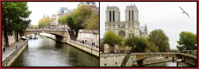
Close to the left bank there is pylon and a statue of St. Geneviève, patron saint of Paris, by Paul Landowski, perhaps best, but not only, known as the sculptor of the “Christ the Redeemer” in Rio (photo from Rio’s official tourism site).


The Pont Louis-Philippe connects Ile Saint Louis with the right bank of the Seine. Dating from 1862 it replaces a previous bridge with the same name from 1833, but which suffered a lot from fire and revolutions (1848-1852 it was called Pont de la Réforme). The name refers to King Louis Philippe who laid the first stone of the first bridge.

Behind the northern end of the bridge I could recommend a visit to the old Rue des Barres and the church Saint Gervais – a very particular atmosphere.

... as well as a short walk to just behind the close Pont Marie to find the Hôtel de Sens, built 1474-1518 with a long and varying story, but today a public library (Forney) specialising in architecture, decorative arts ... and with a collection of about a million postcards.
As a last bridge today, let’s talk about the Pont d’Arcole (celebrating another Napoleon victory). It dates from 1854 replacing a previous pedestrian one from 1828. It gives you the connection between the Paris Town Hall and the Ile de la Cité. It was the first steel bridge in Paris without any intermediate support.


You can find my photos "in full" and as a slide show on Ipernity.

15.11.08

Mid-month theme - subways ... and bridges

Normally I don't post on Saturdays, but the 15th of each month is the day for the mid-month theme “subways”, which I share with bloggers from NYC, Budapest and Stockholm. You can find today’s and some related posts by using the following links:

New York City Daily Blog - Stockholm by pixels - Budapest by Andrea Gerak - Peter's Paris

(You can also find some related posts on my previous blog via this link: PHO.)

As I at the moment am writing something about the 37 bridges which are crossing the Seine in Paris, I will try to combine this with the subway theme.

Most of the Paris metro lines cross the Seine in tunnels. There are a few exceptions; two bridges have an extra level for the metro (Pont de Bir-Hakeim and Pont de Bercy), two are pure metro bridges, the Pont Rouelle and the Viaduc d’Austerlitz.

The Pont Rouelle was built for the 1900 Universal Exhibition to enable a railway link between the “Petite Ceinture” and the Invalides Station. This link is what I put in blue on the below map which shows the Paris railway network around 1900 before the metro started to take over. The “Petite Ceinture” was a circular railway created during the 1850’s with the aim to connect the then existing Paris railway stations of which only a few are still in service – the green / red circles. (One day I may make special post about all this.) On the map I have added, in white, where you can find the Pont Rouelle and the Viaduc d’Austerlitz. The Invalides Station (Gare des Invalides) which was created in 1867 is still there. It served as a railway station until 1935. Since 1948 it’s the Air France terminal for the Orly airport and since 1979 the underground part serves also as a metro station.
The Pont Rouelle (named after a French 18th century chemist) served until the 30’s and then this railway line was abandoned, like the bridge and like most of the “Petite Ceinture”. In 1988, this branch and the bridge were put back into service and are now in use for the express metro network, called RER (line C). As you can see from the below photo, the Pont de Rouelle crosses the Seine over the “Swan Island” (Ile des Cygnes) – as does the Pont de Bir-Hakeim (in the front, see previous post) and the Pont de Grenelle. Just behind the Pont de Grenelle, on the very top of the photo, you can find the Paris copy of the Statue of Liberty (see previous posts).


The Viaduc d’Austerlitz dates from 1905 and is since the beginning solely dedicated to the metro (line 5). It crosses the river in one single metallic span, with arcs above the deck in order to allow a large free space for the navigation. The big stone abutments at each end of the bridge are generously decorated in the style of those days (by J-C Formigé who was responsible for a lot of the Paris metro installations, the parts which are in viaducs, lines 2 and 6).

As with my other "Seine bridge posts", you can see the photos also "in full" and as a slide show on Ipernity.

14.11.08

... and even even more Seine bridges

Again, three more bridges today - I will not be able to finish this week, sorry. We can see these three bridges from the Eiffel Tower (see previous posts) and from a satellite.
There were some plans to make a bridge in front of the Invalides (see previous post) already in 1821. It failed technically and there were also protests about the destroyed perspective. Finally a bridge was built there much later, the Pont Alexandre III, but we will revert to this bridge.

At the end, what was to be called the Pont des Invalides was built a bit downstream, ready in 1829. It was not resistant enough and was replaced in 1855. Some decades later it had to be partly rebuilt and reinforced, but it’s basically the same. The bridge has some nice decorations. The sculpture that you can see (bottom left) is called the Maritime Victory (defeats are seldom celebrated). Somehow I believe that with its naked feet it would as well serve as a witness of the water level as the zouave on the Alma bridge (see my recent post).
The next bridge is the one that was finally constructed in front of the Invalides, the Pont Alexandre III on which I already posted. Here are some photos from the previous post completed by the one on the top of this post, taken recently in a much less sunny weather. This metallic bridge was built in 1900, together with a lot of other monumental buildings, including the Grand Palais (see previous post) and the Petit Palais (see previous post), for the 1900 Universal Exhibition. It was a gift by and got named after the second last Russian emperor. It’s certainly one of the most spectacular Seine bridges.

The last bridge for today is the Pont de la Concorde. Constructed during the Revolution, between 1787 and 1791, some of the material was taken from the just demolished Bastille (see previous post). Depending on the political situation, the bridge has changed name back and forth from Pont Louis XVI to Pont de la Révolution. It finally got its present name in 1830. Basically keeping the same architecture it was doubled in width in 1932 and some further slight modifications have been made later. You can here see what it looked like in 1829, equipped with statues that were later taken away – too heavy.

The bridge leads from Place de la Concorde (see previous posts) to the National Assembly (see previous posts).

You can find these photos in full and as a slide show on Ipernity. (I uploaded also to Flickr on my latest posts, but I don't want to make it in double for ever. Some of you expressed a slight preference for Ipernity, so at least for the moment I concentrate on Ipernity only.)

Exceptionally I will post tomorrow, as it's time for the mid-month theme, subways. I wish you anyhow a nice weekend!

12.11.08

... and even more Seine bridges


Three more bridges today. I guess we have now reached 11 out of 37. (I may not be able to finish this week, sorry.)

Today something about the bridges crossing the Seine fairly close to the Eiffel Tower.

I have recently posted about the Passerelle Debilly.


I made a post about Pont Bir-Hakeim in September last year; just two small photos to remind you... and maybe a few words: This bridge from 1903-05, in two levels to allow the metro to pass, replaced a earlier one from 1878. It got its present name (previously Pont de Passy) from the battle at Bir-Hakeim during WW II.


Then there is the bridge, which is just in front of the Tower, the Pont de Iéna. It was constructed during the reign of Napoleon I and opened in 1814. It got (of course) the name of one of Napoleon’s victories - over the Prussians this time. Later some Prussian invaders wanted to have it desttoyed, but finally accepted just a name change. It rather soon got its original name back. You cannot see so much of the original bridge as it was completely reconstructed in 1937, becoming almost twice as wide.

Here are some pictures taken from the Eiffel Tower (see posts) a couple of weeks ago, one taken in front of the Tower and the bridge, early evening, just when the blue lights had been turned on (see post about the blue, European, Tower). ... and one from the ground, last week, under a much greyer sky.

On the top picture we have a global view of the Pont de l’Alma. The name is referring to another army victory (each country has theirs – Waterloo etc...), this time a bit later, in 1854, and it refers to a battle where the British, Turkish and French troops together fought against the Russians in the Crimean War. An original bridge from 1856, too narrow, was replaced by the present one in 1974.
The original bridge was decorated by four sculptures representing soldiers who had participated in the Alma battle. Of the four, one is still decorating the bridge (it has changed side) and represents a “zouave”, a name given to certain infantry regiments in the French army, normally serving in French North Africa 1831 – 1962, but they participated also in the Crimean war. This statue has served – and still serves – as a popular way of checking the water level in the Seine River, which can vary considerably. This is why you can find walls all along the river when it passes Paris. The footpaths and streets along the banks of the river have now and then to be closed – when the “zouave” gets wet feet. There has been considerable damage due to floods in previous centuries with a number of bridges destroyed. The latest and most important flooding took place in 1910 and you can here see what the old bridge and the “zouave” then looked like.

The place on the northern – right – side of the bridge, Place de l’Alma is decorated with a copy (real size) of the flame of the Statue of Liberty (see different posts) – a gift by the International Herald Tribune to Paris in 1989 (200 years after the Revolution). Under the place is the tunnel where Princess Diana died in 1997 and this statue has become an unofficial place of pilgrimage. On my photo of the flame you can in the background see the fashionable Avenue Montaigne (fashion houses, hotels, theatres...) with the Sacré Coeur in the far horizon. Another fashionable avenue, George V, leads also to this place and just round the corner you can find one of the best seafood restaurants in Paris and also the cabaret Crazy Horse.

You can find these photos in full and in a slide show on Ipernity or on Flickr.

10.11.08

... and even even more Seine bridges


Tomorrow is public holiday and in France many "font le pont" (make the bridge) by not working today, making it to a long holiday including the weekend. Finally (as I'm not working anyhow) I decided to take care of the bridge issue differently.
In addition to the Pont des Arts, two other bridges lead directly from the Louvre to the southern (left) bank of the Seine: Pont Royal and Pont du Carrousel.
A first Pont Royal from 1632, partly wooden, replaced a ferry service. The street leading to this bridge on the left bank is still called Rue du Bac (Ferry Street). Several incidents with this bridge led to the need to construct the present one, built 1685-1689 (see top picture). This is an illustration from the construction (1687) and we can see some of the same buildings as on the top photo: Sainte Chapelle, Notre Dame, the home of our Academies (l’Institut de France)... . The bridge has had different names (during the revolutionary years: Pont National, Pont des Tuileries). This bridge is one of the crossings between the Louvre and the old railway station, now the Quai d’Orsay Museum. On two of the pictures you can see above, taken through the arches of Pont Royal, you can see the next bridge, Pont du Carrousel.

From Port Royal, you have also an excellent view of the Grand Palais - with the Passerelle Léopold-Sédar-Senghor in front.

The Pont du Carrousel looks also quite old, but it was actually built just before WW II (1935-39) and with efforts to make it look fairly similar to the previous one, an earlier bridge from 1831 with different names (Pont des Saint-Pères – after the left bank street leading to it -, Pont du Louvre - and finally Pont du Carrousel). Under the arches of the Louvre, the street prolonging the bridge leads on the right bank to Place du Carrousel, the central square in the middle of the Louvre Palace.
The street along the Seine on the left bank, facing the Louvre, between the two bridges, Quai Voltaire, is quite interesting, not only because Voltaire died in one of the buildings (no. 27). You can find a shop, Sennelier, which since 1887 has equipped most of the famous in Paris working painters with the material needed for their art. (Our former President, J. Chirac now lives a bit higher up in the building.) Ingres, Delacroix, Corot had their studios in one of the buildings. In a still existing hotel (at no. 19), Charles Baudelaire, Richard Wagner, Jean Sibelius, Oscar Wilde, Camille Pissarro... stayed and worked during more or less long periods. These are just examples. There are also a number of exclusive antique and art shops. (On one of the pictures you may see a very narrow building which almost could compete with smallest house in Paris (see previous post), but this one is leads to something quite bigger and fashionable behind the gate.)
You can find these photos "in full" and in a slide show on Ipernity or on Flickr.

I have had the great pleasure to receive this award from some of you, the last one being Ingrid in Cologne. Once more I'm unable to choose to whom in particular to forward it, so I make it to a common award to all my kind visitors!